|
|
|
La Paz and Copacabana, Bolivia
There is something mystical about great altitude. It imparts a spiritual quality to such places as the great ruins of Machu Pichu in Peru and the Himalayan city of Kathmandu in Nepal. The vast stretches of the Altiplano ("high plains") in Bolivia have that quality. Nicknamed the Tibet of South America, the Altiplano is at an air-impoverished 13,500 feet - a height equivalent to the average base camp on Mount Everest. This barren, windswept plateau framed by the craggy, snow-capped Andes has an intangible, ethereal ambience that will give pause to even the most jaded visitor. It is the perfect site for the annual pilgrimage that has taken place here for thousands of years.
La Paz
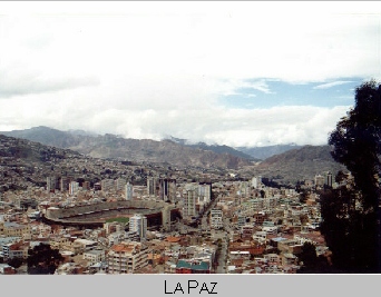 The
capital city of La Paz is nestled on the steep slopes of a valley that
plunges from the heights of the Altiplano. The air terminal for La Paz,
the John F. Kennedy Airport, is in the suburb of El Alto ("The High"),
perched on the edge of the Altiplano overlooking the city.
The
capital city of La Paz is nestled on the steep slopes of a valley that
plunges from the heights of the Altiplano. The air terminal for La Paz,
the John F. Kennedy Airport, is in the suburb of El Alto ("The High"),
perched on the edge of the Altiplano overlooking the city.
The airport is so high that the aircraft landing there can barely slow down without losing the lift that sustains their wings. It is so high that, on final approach, the crew must actually depressurize the aircraft cabin from the 7,000 foot virtual altitude maintained during the flight for the passenger's comfort. At the altitude of the airport, a significant number of people who, like myself, came from sea level, will suffer from the low air density. The low air density means less oxygen per lungful and we breathe harder to compensate. As we breath harder, we exhale too much carbon dioxide and our blood acidity level begins to plummet. Low acidity of our blood (alkalosis) results in headaches, nausea, sleep disturbances and weakness. These symptoms of altitude sickness or "Acute Mountain Sickness" may last several days until our bodies adjust to the scarcity of oxygen.
I tried not to think of these things as my flight came screaming into
El Alto. I looked out the aircraft window, and was mesmerized by the sight
of Mount Illimani thrusting upwards through the clouds. Although this mountain
looms over the city, during the early part of the year, it is 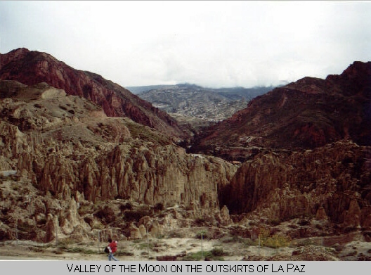 obscured
by a constant overcast, making this glimpse from the aircraft the only
one many will see.
obscured
by a constant overcast, making this glimpse from the aircraft the only
one many will see.
After descending to La Paz (which is only at 12,300 feet), I tried to follow the advice of articles I had read in order to avoid the splitting headache I had suffered on my last visit to Bolivia. That advice was to avoid strenuous activity and drink a lot of "mate de coca." The mate is a tea made from coca leaves which is used to alleviate the "soroche" or altitude sickness. While I was interested only in its medicinal effects, I was sharing in a 4000-year-old custom that was considered sacred in the Andean culture. Although the coca leaf is the source of cocaine, the processed cocaine powder contains nearly 99 percent of the active ingredient (cocanine), while the natural coca leaf contains only 0.4 percent. Nevertheless, drinking the tea will make you flunk a drug test and the tea cannot be imported to the United States without special permits from the USDA, Customs and the DEA.
Pre-columbian South American Indians learned that chewing coca leaves gave them increased stamina, an ability to go long periods of time without food or sleep, and blocked the sense of fatigue and cold. During the time of the Incas (1200 A.D.-1500), the rulers attempted to restrict the use of the coca plant to royalty, shamans, doctors, and messenger runners. The Catholic church, which followed the conquistadores into the New World, banned the leaves altogether. Yet, coca remained a central part of the Andean peoples lives. It was, and still is, used in religious rituals performed at birth, at death, and at important occasions in between. My use of the coca tea, however, had no spiritual or even medicinal effect. By that afternoon I was confined to my room with the kind of excruciating headache that makes it difficult to even read.
Fortunately, by the next morning, I was ready to explore the nearby Tiwanaku (also spelled Tiahuanacu) ruins, billed as Bolivia's most important archeological site. It is less than 4% excavated and only last year did Bolivian archeologists receive the funding to start restoration in earnest. Right now, the pyramid, Akapana, which would have been the most imposing structure, is nothing more than a pile of dirt. At the top of this mound, there are several boulders of purported mystical power. Mystical or not, they do have a measurable magnetic power which can be demonstrated with a compass.
Adjacent to Akapana is the sun temple known as Kalasasaya and the sun gate. The sun temple now little more than a low-walled platform was constructed to make astronomical observations and was arranged so that, at the solstices, the sun appears directly overhead certain calibrated points.
The only fully-restored edifice is the semi-subterranean temple, a sunken room that appears to be about 50 feet square. In reality, it is not square, but rectangular with its longer dimension aligned with the location of another temple miles away. The walls of the temple are decorated with dozens of faces carved from stone, each of which represents a different tribe or ethnic group of which the Tiwanaku empire was comprised. At the center stands a stone deity who wears a "mask" that looks remarkably like a mustache and goatee. It strikes me as odd that, even as a mask, such an affectation would have been imagined by this pre-Columbian, and beardless, culture. This has caused some to speculate that South American Indians had encountered westerners long before Columbus arrived in the Carribean. Similarly, representations of sea creatures, such as crabs, on the belt of this deity, suggest that the sculptors had some knowledge of the oceans which lie hundreds of miles from the highlands of the Altiplano.
Copacabana
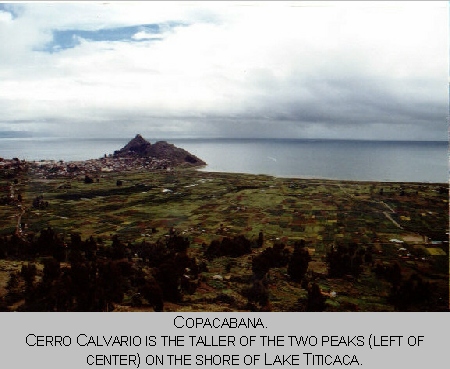 On
Friday, I hit the road bound for Copacabana. Copacabana is a town on the
shores of Lake Titicaca and is the place from which the well-known Copacabana
Beach in Rio de Janeiro took its name. It is also famous for
being the destination of a traditional pilgrimage undertaken by the most
devout of the region's large Catholic population. That pilgrimage was taking
place on this very week, the Holy Week before Easter Sunday.
On
Friday, I hit the road bound for Copacabana. Copacabana is a town on the
shores of Lake Titicaca and is the place from which the well-known Copacabana
Beach in Rio de Janeiro took its name. It is also famous for
being the destination of a traditional pilgrimage undertaken by the most
devout of the region's large Catholic population. That pilgrimage was taking
place on this very week, the Holy Week before Easter Sunday.
The road to Copacabana begins at the tattered town of El Alto. Until recently, El Alto was a part of La Paz, but is now a separate municipality. It has become a magnet for the campesinos (country folk) who cannot afford to live in La Paz proper. This influx has grossly overburdened El Alto's near nonexistent infrastructure. As a result, the town is a stark picture of poverty, dirt, and broken-down shacks. Its mostly unpaved streets are overflowing with people - many of the women in their traditional garb consisting of brightly-colored shawls and English-style bowler hats.
In El Alto, I pass the turnoff for the road to Oruro to the south. Oruro is a small, industrial city on the Altiplano and a destination fairly unknown to tourists. To get there, you can either charter a small plane that will be flying at an altitude higher than was ever tested or approved by the manufacturer, or you can brave what the locals call the "Road of Death." I had earlier traveled to Oruro and had concluded that the foreboding moniker for this two-lane, arrow-straight road was more applicable to pedestrians than to travelers. During our trip, we very nearly killed two women, a small child, and a dog when they darted in front of us. Each of these near misses prompted every passenger in the car to slam on his or her imaginary brake pedal.
The worst part of the "Road of Death" was the stretch still within the town of El Alto where the road was under construction. The detour took a parallel route that could only be called a road in the broadest, pre-invention-of-the-wheel sense. Four wheel drive was a necessity here as our jeep, and an endless jumble of vintage cars and buses, slogged crazily along a path that was at the same time a mud-slinging quagmire and a bladder-bruising washboard. At one point, our driver tried to pass a bus just as another bus careened towards us from the opposite direction. Unable to get back behind the bus we were passing, our jeep was trapped in the much-too-narrow space between the gargantuan juggernauts. This time every passenger slammed on his or her imaginary "get very skinny" pedal.
The road to Copacabana, however, is far less difficult to negotiate. We soon left the busy streets of El Alto behind, and began our trek across the Altiplano towards Lake Titicaca. The terrain here is as flat as a billiard table and barren of any vegetation taller than waist high. The land is pocked with low adobe walls forming enclosures. They look almost as if someone were building an adobe house, but abandoned the project before putting on a roof. The enclosures sometimes surround a shack, but many times are completely empty. I am told that these walls of mud and straw are the means by which one stakes a claim to that land.
My guide pointed proudly to a group of adobe homesteads, each of which was accompanied by a smaller shack painted white. "Look at the progress we have made here," he said. "Those white buildings are toilets." Only later that day, when I myself was looking for a bathroom, did I fully comprehend that any facilities at all, even an outhouse, is truly a modern convenience in the Bolivian back country.
 The
pilgrimage was fully underway. The road was packed with buses, cars, bicyclists,
and pedestrians all making their way to Copacabana. There, they intended
to pay their respects to La Virgen Morena (also Virgin of the Lake and
La Virgen de Candelaria, the patron saint of Bolivia) in the Cathedral
and to climb the Cerro Calvario (Calvary Hill).
The
pilgrimage was fully underway. The road was packed with buses, cars, bicyclists,
and pedestrians all making their way to Copacabana. There, they intended
to pay their respects to La Virgen Morena (also Virgin of the Lake and
La Virgen de Candelaria, the patron saint of Bolivia) in the Cathedral
and to climb the Cerro Calvario (Calvary Hill).
Copacabana is located on a peninsula with the same name that extends from the Peruvian side of the lake. To get there from the Bolivian side, you must take a ferry across the strait of Tiquina. This waterway is only several hundred yards across and seems to beg for a bridge. For now, travelers arriving in buses and cars must leave them and board small boats for the trip to the opposite shore. Meanwhile, the vehicles are ferried across separately on tiny barges.
Tiquina is also the base for Bolivia's landlocked navy. A billboard reminds visitors that Bolivia once had access to the Pacific. Chile snatched Bolivia's corridor to the sea in The War of the Pacific (1879 -1884), a fact that still raises the ire of many Bolivians.
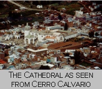
Upon reaching Copacabana, I first visited the chapel where the worshipers burn candles as part of their religious experience. Then I visited the Moorish-style Cathedral itself where the Virgin is on display. The Virgin was carved back in the 1580's by an Indian artist, Tito Yupanqui, the purported grandson of an Inca emperor.
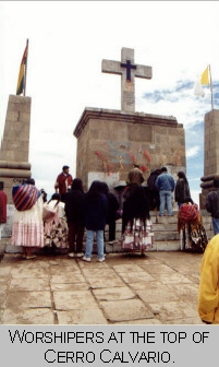
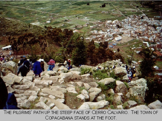 I
then made the arduous climb up the hill to the shrine on top. Along the
way, I passed stations of the cross where tradition requires believers
to leave stones (representing their sins) that they have lugged up the
hillside. I also passed several examples of "mestizaje," the blending of
different religious beliefs. The pre-Inca Andean myths have combined with
the beliefs of the Inca conquerors and the Catholic practices of the Spanish
conquerors. Indian holy men bless the pilgrims and throw powdered incense
on hot coals to create a cloud of smoke to lift away their sins. The holy
men consecrate the "offerings" of the pilgrims --miniature versions of
the material goods they aspire to own. These "offerings," which include
miniature cars, homes, American money, and even passports, are for sale
along the side of the trail. By tradition, the holy men finish each ceremony
with a swig of beer. By mid-afternoon when I was there, they were already
pretty intoxicated from having performed so many ceremonies.
I
then made the arduous climb up the hill to the shrine on top. Along the
way, I passed stations of the cross where tradition requires believers
to leave stones (representing their sins) that they have lugged up the
hillside. I also passed several examples of "mestizaje," the blending of
different religious beliefs. The pre-Inca Andean myths have combined with
the beliefs of the Inca conquerors and the Catholic practices of the Spanish
conquerors. Indian holy men bless the pilgrims and throw powdered incense
on hot coals to create a cloud of smoke to lift away their sins. The holy
men consecrate the "offerings" of the pilgrims --miniature versions of
the material goods they aspire to own. These "offerings," which include
miniature cars, homes, American money, and even passports, are for sale
along the side of the trail. By tradition, the holy men finish each ceremony
with a swig of beer. By mid-afternoon when I was there, they were already
pretty intoxicated from having performed so many ceremonies.
 Also
along the trail are fortune tellers who will read your future from nuggets
of silvery metal. This metal is first heated until it is liquid and then
poured into water where it hardens into shapes that, to the trained eye,
reveal the future of whoever is paying for this procedure.
Also
along the trail are fortune tellers who will read your future from nuggets
of silvery metal. This metal is first heated until it is liquid and then
poured into water where it hardens into shapes that, to the trained eye,
reveal the future of whoever is paying for this procedure.
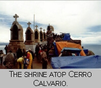 At
the top of the mountain, caged birds tell the fortunes of the pilgrims
by selecting small strips of paper from a cup. Much like those inside fortune
cookies, these paper strips are printed with predictions and fragments
of conventional wisdom. Another space is set aside for the pilgrims to
stake their claim to symbolic plots of land. These plots, about a square
foot in size, are demarcated by small stones and are representative of
the real plots of land they hope to own someday.
At
the top of the mountain, caged birds tell the fortunes of the pilgrims
by selecting small strips of paper from a cup. Much like those inside fortune
cookies, these paper strips are printed with predictions and fragments
of conventional wisdom. Another space is set aside for the pilgrims to
stake their claim to symbolic plots of land. These plots, about a square
foot in size, are demarcated by small stones and are representative of
the real plots of land they hope to own someday.
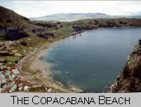 The
thin air here is clear and crisp. In the distance are the Andean peaks
in Peru. The smooth, turquoise surface of the lake below envelops three
sides of the Cerro. It is easy to understand why this place has been regarded
as holy ever since the first Indian settlers arrived here. To walk here
with the pilgrims is to experience the simplicity and purity of their purpose
and to tread in the footsteps of many before.
The
thin air here is clear and crisp. In the distance are the Andean peaks
in Peru. The smooth, turquoise surface of the lake below envelops three
sides of the Cerro. It is easy to understand why this place has been regarded
as holy ever since the first Indian settlers arrived here. To walk here
with the pilgrims is to experience the simplicity and purity of their purpose
and to tread in the footsteps of many before.
Thomas E. Ice
P.O. Box 310053
Miami, FL 33231-0053
(305) 476-1581
ice@ice.htmlplanet.com
© Copyright 1999 Thomas E. Ice